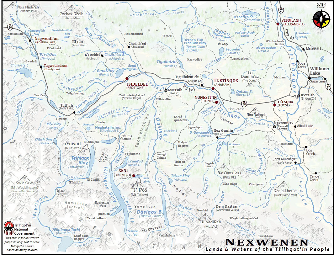
Place names are of deep ancestral significance to Tŝilhqot’in people. They connect language, history, cultural practice, traditional knowledge, and mythology to the places and features that make up Tŝilhqot’in territories. Reflected in our place names are our histories, myths, and legends, as well as the unique physical geographies, ecosystems, and environments of our ancestral homelands. As such, place names also provide evidence for Tŝilhqot’in historical land use and occupation, indicating where our ancestors held deep relationships with lands and waters, plants and animals, and spiritual beings.
Tŝilhqot’in place names also reflect the richness of our language, Nenqayni Ch’ih. Many places have more than one name, and there are often two, three, or even four versions of any one place name. This variation is a reflection of the diversity of our language speakers, as well as a long, often ancient history of using these names. While many Tŝilhqot’in place names have a meaning that can be understood by translating their components (i.e. Tsalhanqox = tsa [beaver] lhan [many] yeqox [river]), many have been used for so many generations that they can no longer be translated in this way. As with most Indigenous cultures, Tŝilhqot’in place names are ancient and dynamic, preserving memories as far back as creation, but also reflecting the evolving nature of language, cultural practices, and historical events.
Tŝilhqot’in elders carry an incredible amount of knowledge about Tŝilhqot’in place names, and this knowledge has been passed down orally for countless generations. While Tŝilhqot’in oral systems are still strong, we also use modern technologies to preserve and celebrate the richness of Tŝilhqot’in place names. Today, geographic information systems (GIS – computerized mapping software) are used to safely store information about place names, and present them in the correct location whenever a map needs to be made.
Over 800 Tŝilhqot’in place names have been carefully documented and mapped by Tŝilhqot’in members and TNG staff since the 1990s, but many other names carried by Tŝilhqot’in Elders have not yet been recorded into our modern system. Sadly, some names may have been lost due to destructive forces such as the intentional spread of smallpox in the 1860s, the devastating effects of the Spanish Flu and other diseases in the 19th and early 20th century, the establishment of Indian reserves separating many families from the land, the residential school system, and other forces of culture and language suppression and disruption. Despite these challenges, Tŝilhqot’in connections to place names remain strong.
Tŝilhqot’in Place Names “On The Map”
As outlined through Section 12.43 to 12.48 of the Nenqay Deni Accord, the Tŝilhqot’in National Government has been working with the Geographical Names Office of the Heritage Branch of the Ministry of Forests, Lands, Natural Resource Operations and Rural Development (FLNRORD) to recognize and officially adopt Tŝilhqot’in place names into Provincial records. This process will ensure that Tŝilhqot’in place names are reflected on official maps of BC.
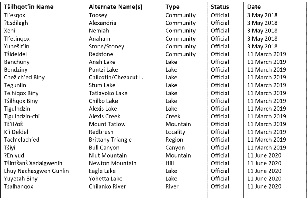
With support and direction from each of the Tŝilhqot’in communities, TNG has been submitting information about Tŝilhqot’in place names (including the name and spelling, location, pronunciation, meaning, etc.) to the BC Geographical Names Office so that they may become officially recorded and adopted. See the below chart of the 23 place names adopted by BC as of June 2020:
Contact
For more information about Tŝilhqot’in place names, contact Shane Doddridge, TNG Cultural Heritage Coordinator: shane@tsilhqotin.ca